Field Trip Day 4 - Glenn Highway & Matanuska Valley Area
Overview of Trip
This trip takes one last look at the McHugh formation, then focuses on the Peninsular
terrane. Differences in the Chugach and Peninsular terranes are high-lighted.
Stop 1 - McHugh Formation along Border Ridge Fault
Location: On the old Glen highway north of Eagle River, turn right on Rachel, by
SBS. Make another right on Beaujolais Drive, then park in one of the circle drives.
Walk behind the houses back to the 50’ tall cliffs.
Description: An old quarry with a housing development being built in it. The rocks
are a mix of angular and well rounded with no apparent sorting. Size ranges from
powder to boulders. Lots of meta-conglomerates, some green colored rock. As you
walk towards the hills, the rock becomes more competent and there is a cliff. Much
of the rock is red stained and crumbles in your hand.
Looking to the west, the topography is rolling hills and the Cook Inlet. To the
south and east, the Chugach Mountains rise overhead.
Interpretation: These rock are part of the McHugh formation in the Chugach terrane.
This area is located along the Border Ranges fault where the actual fault movement
occurred. This resulted in a zone of broken material, fault gouge, angular rocks,
slickensides. The red color is due to groundwater leaching out iron from surrounding
soils and redepositing the iron in the now permeable fault zone. A quarry was started
here because the broken up McHugh formation is easy to mine. They stopped when they
reached the more competent rock not broken up by the fault.
Several lakes and streams are located along the Border Ranges fault. A local creek
runs down an eroded section located in the weakened fault zone. Upper Fire Lake
is also located along this weakened area. They form in depressions resulting from
fault zone material removal.
The presence of the housing development raises issues of geology versus economic
interests. As the Anchorage bowl area gets built out, there is increasing pressure
to use less desirable areas for housing and commercial development. There are numerous
buildings in Anchorage constructed on old peat bogs that have been excavated and
refilled with gravel. This particular housing development is of concern because
of its location right on the fault zone. The role of Governments in informing citizens
of geologic hazards, regulating development through zoning and re-inbursing landowners
when they experience a loss due to poor site selection are issues that Anchorage
citizens are having to deal with more and more frequently.
Stop 2 - Bedrock Outcrop
Location: The 1st Birchwood exit off the Glens Highway. Stop on the right side of
the off ramp beside the cliff outcrop.
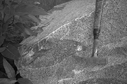
Description: A tall (40-50’) outcrop of hard,well consolidated rock. Located at
the base of the Chugach Mountains. The rock is dark gray and black with white layers
swirling through it. There are lots of fractures and folds. A light colored 2-3’
wide dike cuts through the outcrop.
Interpretation: This is part of the Peninsular terrane. The rock is basalt and chert
that has been deposited in a deepwater marine environment, then metamorphosed. These
rocks have undergone a higher degree of metamorphism than the rocks in the McHugh
formation. They are also much older - Jurassic vs. Cretaceous age. Paleo mag studies
also indicate they have moved further, 20 degrees from the equator versus 40 degrees
for the Chugach terrane. The dike is an andesite prophery - white fine grained igneous
rock that has been extruded up into the overlaying rock.
Stop 3 - Railroad Quarry in Eklutna
Location: Take the Eklutna exit off the Glenn Highway. Drive north over the overpass
past Eklutna village to the railroad quarry. Park by the gates.
Description: Several “No Trespassing” signs were located next to the locked gate.
Large boulders are positioned along the road access to discourage trespassing. The
boulders are 3-5 feet in diameter and are white colored with small crystals. Several
train cars containing broken up pieces of this material were noted on the train
tracks.
Interpretation: The rock is classified a grano-diorite, an intrusive igneous rock.
Darker colored areas can be found in the rocks (see picture). These are xenoliths,
country rock that fell into the magma chamber and didn’t completely melt and diffuse
into the the magma. Slickenside type structures were noted on several surfaces,
usually associated with faults and sliding events. Feldspar and a green material
were noted on the surface. The green mineral on the surface is epidote, a mineral
associated with late stages of igneous intrusion formed when superheated fluids
move through rocks. There is a network of fine, white veins - the rock can break
preferentially along these veins.
The deposit the rocks came from is a pluton. Plutons are formed when magma is forced
up into overlaying rock, then the softer surrounding rock is eroded away. Plutons
are on the small end of the intrusion scale, about 6 X 6 city blocks big. Stocks
are small plutons while batholiths are much larger intrusions.
Stop 4 - Matanuska Lake
Location: This stop is in the Bradley-Kepler park. Drive north on the Glenn Highway
past the Parks Highway turnoff. Turn left into the park.
Description: A large lake with a grassy slope behind it. The slope is steep, long
and narrow. An active quarry is located nearby.
Interpretation: This area is also known as the crevasse moraine park and is thought
to be an esker complex. Eskers are formed under the glacial ice and result in deposits
with sorted sand and gravel, and have layers and stratification. Roads are commonly
built along their tops as they are frequently topographic highs, running above any
marsh areas.
In the Palmer area, there was rapid retreat of the glaciers from the Matanuska and
Knik valleys. They retreated approximately 100 miles over 2000 years (12,000 - 10,000
years BP). This was too rapid a retreat for the ice to organize and drop new material.
Stop 5 - Matanuska River Overlook
Location: Along the Glenn Highway, approximately 1 mile east of Palmer in roadside
park.
Description: From a parking lot adjacent to the Glenn Highway, walk 50 yards around
a fenced walkway and viewing area to a cut bank overlooking the Matanuska river.
There is a steep drop to the river. The cut band has exposed a section consisting
of sand, loess and gravel. Looking up and down the river, numerous channels and
an absence of vegetation was seen. While driving to this stop, several “steps” were
driven up.
Interpretation: The Matanuska river is eroding down into old glacial deposits. It
is constantly switching channels due to having a glacier as it’s source. During
the day, water flow off the glacier increase as heat from the sun warms it. Higher
water flow rates increases the rivers carrying capacity. At night, the flow rate
drops and sediment settles out in the active channels. The next day, these channels
are partially plugged and the river finds a new channel. This results in a highly
braided stream complex and a lack of vegetation in the stream basin.
The cut bank has a sand layer on top. This is from high winds blowing down the Matanuska
valley picking up sand size particles from the gravel bars in the river valley and
redepositing then on top of the bluff. A number of sand dunes are located along
the highway in this area. Below this is a layer of loess, wind blown silt with several
ash layer from volcanic eruptions. Under this is a layer of gravel and sand, showing
stratification and bedding structures. The lower most exposed section is a poorly
sorted layer of glacial till with no stratification, containing much more fine material.
Looking across the valley, several steps are apparent. These represent previous
levels of erosion by the river. Down river, the Brodenburg Butte can be seen rising
above the river plane. The butte is a pluton composed of a grano-diorite rock that
is more resistant to weathering and erosion than the surrounding rock. It appears
to have a Roche moutonnee profile from glaciers riding over one side and pulling
off large blocks of rock from the downstream side.
Stop 6 - Chickaloon Formation, Coyote Lake Park
Location: Coyote Lake Recreation area. Drive out the Glenn Highway to Sutton, turn
left on Jonesville Road. Drive down a gravel road approximately 3 miles to the park.
Description: An old coal quarry that was active prior to 1945. Coal beds are present,
along with petrified wood and leaf fossils. A lake has formed in the basin where
coal was extracted. The surrounding mountains have several layers of coal and are
highly tilted.
Interpretation: These rocks are part of the Chickaloon formation, tertiary age rocks/fill
on top of much older Jurassic age rocks. The coal is sub-bituminous, a higher grade
than lignite but still relatively low quality. When coal samples are broken along
fracture planes, leaf imprints/fossils can be found. Fossils found include sequoia/meta-sequoia
needles and broader leaves from hickory and elm trees. Iron concretions are also
found in the less consolidated layers. These typically start at a fossil node and
pH changes form an area that attracts iron and other minerals into a spherical concretion.
Occasional white, igneous rocks are found - these are from the Talketnas, the closest
batholith.
This area is bounded by the Border Ranges and Castle Mountain fault. It is downthrown
and subsiding, allowing sediment to accumulate. Sediment thickness is estimated
at over 5000’. This mine is located along the Wishbone Hill syncline. A coal mine
has been proposed to be re-opened up the mountain, but has been delayed due to permitting
problems.
References
Chernicoff,S., Fox,C. and Venkatakrishnan,R., 1997, Essentials of Geology, Worth
Publishers
Conner,C. and O’Hare,D., 1988/1993, Roadside Geology of Alaska, Mountain Press Publishing
Company
Chugach Gem and Mineral Society, 1986, Alaska ... A Guidebook for Rockhounds, Glacier
House Publications
Zimmerman, J., 1993, A Naturalists Guide to Chugach State Park, A.T. Publishing
and Printing