Tombstone Mountain Backpacking Trip
August 1996
by Joe Anders
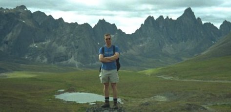
Ted Cahalane had been wanting to go hiking in the Tombstone range ever since he'd picked up a guidebook while in Dawson City several years ago. Remote and very rugged, scenic, accessible by car, lots of history - and fantastic granite spires rising several thousand feet above the valleys. In August '96, Ted and I spent 4 days hiking in the Tombstone range. The Tombstone range is located approximately 40 miles/70 km north of Dawson City. The Canadian government maintains a visitor center and a small campground at km 71. During the summer, a ranger/naturalist stays at the center. Ted and I had hoped to do a loop around Tombstone mountain, but significantly toned down our goals after we got a good look at the terrain.
 Day 1: Anchorage to Tombstone
Off to an early start. We had the Glenn Highway all to ourselves - didn't get stuck behind any RV's or "sportsmen" towing their 4-wheelers. Made great time to Tok, then headed north on the Taylor Highway. It's a dirt road and was in great shape - no delays. There were several mining operations along the road, but no one was mining the road. An old abandoned dredge is next to the road and is fun to explore. The 40 Mile River winds through the valleys and the road crosses it several times - I put canoeing it on my things to do list. It's interesting how on the US side of the border, the road winds through the valleys, then once past customs on the Canadian side, the road runs along the ridges. Customs was a non-event and we stopped in Dawson City for an hour or so to check out the tourist scene. From Dawson City, we headed east 13 miles on the Klondike Highway, then north 40 miles on the Dempster highway. 582 miles later, we had made it!
We visited with the Naturalist/Ranger person at the visitor center (km 71) and were disappointed in how little she knew about the backcountry. We asked her about hiking to Grizzly Lake, and she responded by commenting she had tried to get back there once, but gave up half way. Don't depend on any information for trip planning from these folks! We spent the night at the campground.
Day 2: Garbage Dump to Grizzly Lake.
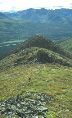 The guidebook (see below) Ted and I used to plan our trip describes 3 road access points to the backcountry. The thing to keep in mind is there are no trails up the valleys and vegetation is very thick - bushwhacking hell. Getting up on the ridges is the best option, though it adds a lot of elevation gain - something to look forward to with backpacks on and lots of scrambling required. At km 54, Wolf Creek is one option. There is no trail and the vegetation was rumored to be thick and especially nasty. The area garbage dump is located at km 58. There is a small parking area and, more importantly, a trail that gets you above the vegetation and onto a ridge leading back to Grizzly Lake. The last access point is from the visitor center/campground, km 71. This didn't look too attractive - we were told the promising trail leaving the campground ends after a mile or so and it's bushwhacking hell for miles after that.
We parked at the dump and headed up the trail. After a mile or so, the small, unimproved trail leaves the creek and starts to climb a ridge. The trail faded away after a couple of miles and we continued to gain elevation. We encountered 2 parties that were coming out. Both counciled that we stay high and keep gaining elevation, even though it looked like we could sideslope around to Grizzly Lake. There was a promising looking ridge that we considered taking down, but decided to go ahead and eat the extra elevation gain and stay high - good thing, because that ridge would have dropped us into the valley too early.
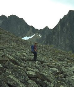
It's worth mentioning what type of backcountry experience this is. This is a totally undeveloped area. There are minimal trails, no people, very rocky ridges to walk & traverse - extra strenuous hiking conditions. Your map reading and route finding skills need to be sharp. The weather can get cold & wet quickly (as we found out!). It's very sparsely traveled - Ted and I did not see any more people after the first day.
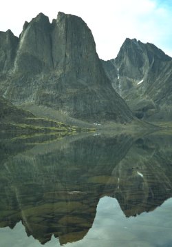
We arrived at Grizzly Lake and set up camp. The area was beautiful - we were surrounded by granite walls, Grizzly Lake was a clear blue color and there were few signs that anyone had ever been there before. We hiked up towards Perilous Pass - it deserves it name, I wouldn't want to have to go over that pass.
Day 3: Grizzly Lake to Batholith Brink
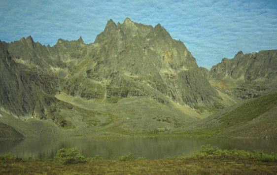
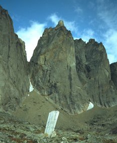
Rotten weather - low cloud ceiling, fog and cold drizzle, didn't get out of the tent until 1:00.. I was content to lay in my sleeping bag and let my poor body recuperate from the previous days trashing, but Ted was itchy to get going. The weather started to clear, so we left our camp and hiked up a ridge and over Grizzly Pass. From here, we could see down Wolf Creek valley towards the road, back towards Panorama Peak and over Wolfe Pass. Wolfe Creek did look awfully brushy. If you were to hike up Wolfe Creek, get on the ridgeline as soon as possible - the view is much better and you will end up gaining the same amount of elevation. We hiked down a ridge, crossed Twin Lakes creek then hiked up a valley towards Batholith Brink. It was wonderful hiking - alpine meadow, minimal brush, no bugs, vertical walls rising 1500 - 2000 feet above us on each side and a stunning mountain standing at the top of the valley. After passing several small lakes, we reached the head of the valley, a ridge that lets you see up and down the Tombstone River drainage. We were treated to views of the front of Tombstone Mountain. The faces on the South side of the drainage are near vertical for 2000 - 3000 feet and are really spectacular. We admired the scenery until we had to leave if we didn't want to hike in the dark, the backtracked to Grizzly Lake.
Day 4: Grizzly Lake to Mount Monolith
This was the day that really made the trip. We woke up to beautiful skies and decide to hike around to the base of Mt. Monolith.
Day 5: Grizzly Lake back to the dump
More crummy weather. This time it was wet snow and more fog/low clouds. Ted and I keep hoping it will stop, but it gets colder & wetter and starts coming down faster. We wait as long as we can, then decide to hike out in the snow, so we load up our packs and set off. Even though our truck is 1500' below us if we hike out the valley, we head up towards the ridge. 1000' later, we're on the main ridge, trying to pick the right ridge to hike down on. Low cloud cover reduces visibility to several hundred feet at times and we worry about going down the wrong ridge. Several ridges look like the right ones, but we know if we pick the wrong one, we could end up bushwhacking out dense brush. Even though it's pretty foggy, the visibility occasionally improves enough for us to feel confidant we are heading the right way. We end up going down the right ridge and find the trail that leads us back to the dump without too much bush whacking.
After a total of 50 miles & 17,000 vertical feet, back at the truck. The beauty of this area has to be seen to be fully appreciated. It is incredibly rugged. No trails in the valleys force hikers onto the rugged ridges, adding 1000's of feet of elevation to any trip. It will probably be a few years, but this is a place that my kids will need to see!
Trip Planning Resources
The maps that cover the Tombstone range are:
1:50,000 116 B/7 "Tombstone River"
1:50,000 116 B/8 "Upper Klondike River"
1:250,000 116 B & 116 C "Dawson"
You can order maps from:
Jim's Toy and Gift
(403) 667-2606
(403) 668-7706 Fax
A good guidebook is "Along the Dempster" by Walter Lanz. It contains route descriptions around the entire Tombstone area. A must if you are planning a trip without consulting someone that's been there. The author must be some sort of superhiker - some of the routes he describes should only be attempted after an exploratory trip to see what you are getting into. Plan an easy trip to scope out the terrain before you embark on anything that puts you in the valleys or attempt loop around Tombstone Mountain. About $15.00, you can order from:
Oak House Publishing
3814 West Tenth Avenue
Vancouver, British Columbia, Canada